

Imagine heading home from a long day at work, only to have your phone's GPS glitch out completely. Could you still find your way? It's a reminder of how much we rely on Global Navigation Satellite Systems (GNSS) for everyday guidance, from getting around to discovering new spots. This tech has quietly become a staple in our routines, offering reliable accuracy without much thought.
Taking a cue from that, Real-Time Kinematic (RTK) positioning—which builds on GNSS signals for its core data—has gained traction in robotic lawn mowers. It delivers pinpoint accuracy down to centimeters, making yard upkeep smoother and more precise. But does modern RTK measure up to the seamless smarts of smartphone GNSS? Can it truly guide mowers to exact spots and streamline mowing? Let's break it down.
1. Key Positioning Systems for Robotic Lawn Mowers
1.1 RTK Positioning Technology
RTK, or Real-Time Kinematic, is a differential method that uses carrier-phase signals to hit centimeter-level accuracy, far surpassing standard GPS setups. What makes it so effective boils down to three key elements:
1.1.1 It measures the full carrier wave phase for distance, boosting precision by 100 to 1,000 times over basic signal timing.
1.1.2 It cross-checks data from a nearby base station to cancel out common errors like atmospheric delays.
1.1.3 The main hurdle—figuring out the exact number of full wave cycles (known as integer ambiguity)—gets solved through clever algorithms, locking in that tight accuracy.
In essence, RTK pulls together detailed phase readings, error corrections, cycle counting, and ways to cut down on signal bounces for reliable, close-range fixes. Picture going from the length of a couple of cars to the width of a thumbnail—that's the leap for backyard boundaries. Mowers can now stick to exact zones, much like roombas hug room edges without wandering.

Real-time corrections between base and mover happen fast, with updates from 1 to 20 times per second, giving near-instant responses at millisecond speeds. Broad signal reach also tackles bounces from buildings or trees, softening local glitches.
That said, RTK isn't invincible. It leans heavily on clear satellite views for both base and unit, so spotty coverage or heavy shade can throw it off. Setup demands some know-how too, from installing stations to troubleshooting, which can slow wider use. Still, it's the top choice for mowers, with makers tweaking it further through add-ons like these.
1.2 VSLAM: Affordable and Quick to Adapt
Visual Simultaneous Localization and Mapping (VSLAM) is another popular pick, drawing interest for its budget-friendly setup and fast response to changes around it.
VSLAM taps visual cues to map and place the device in real time, blending computer vision, robot controls, and sensor feeds. It builds maps on the fly while nailing the unit's spot in unfamiliar spots. Usually, it uses cameras—single, paired, or depth-sensing—to grab images, then pulls out landmarks like edges or points with tools like SIFT or ORB. Matching those lets it figure pose (position and angle), growing a 2D or 3D layout step by step.
At heart, it's the robot "seeing" as it goes: snapping views, stitching a current map, and deciding moves based on what's ahead. You'll see it in drones, vacuums, and self-driving cars.
But it's not without catches. Crunching image floods in real time needs hefty computing muscle and solid hardware. Lighting shifts, bland colors, or bad weather like rain can fuzz the map, stalling progress. And since it's camera-only, range stays limited.
1.3. Lidar Slam: Sharp and Steady in Tough Spots
Lidar SLAM uses laser radar for on-the-spot mapping and locating, spitting out 2D or 3D scans as point clouds or wireframes. Like VSLAM, it maps as it moves, but swaps cameras for lidar pulses that bounce back for distance reads, building dense environmental data.
As the mower rolls, each laser sweep adds to the map, sharpening its sense of place. It outshines VSLAM in detail, especially in cluttered urban or indoor scenes, where cameras might blur. Lasers ignore light levels, working fine in dark or glare.
The flip side? Cost. Lidar floods data that chews processing power, hiking software needs and prices. VSLAM leans on cheaper, off-the-shelf vision tools with tons of free code options, so lidar setups can run several times pricier from sensor to full system. That's why VSLAM often wins for everyday builds.
1.4. UWB: Strong Indoors, Tricky Outdoors
Ultra-Wideband (UWB) uses broad radio waves for close-range tracking and measuring, hitting sub-meter or centimeter marks mainly inside. It punches through walls well, holding up in messy indoor spots for things like tracking gear or people.
A big plus: it handles multiple devices at once for positioning and chat. That's why it's creeping into outdoor mowers.
Range caps at 30-100 meters, though, so big yards might need extra relays or stations, adding hassle. It also relies on scattered anchors for fixes, ramping up install and upkeep costs. Great for tight spaces, less so for open lawns.
Feeling overwhelmed? No single tech nails it perfectly.
2. Finding the Best Mix for Mower Positioning
Looking at the pros and cons, no one's a silver bullet—each has gaps. Smart mower brands often layer them, with RTK as the anchor for its balance of strengths. The trick is pairing it right to cover weak spots.
2.1. RTK + UWB? Not Optimal
Could UWB patch RTK's satellite blind spots? RTK shines if coverage and interference get sorted—plenty of satellites mean you can dot bases around for wide lawns. But UWB for interference? Dicey.
UWB needs anchors everywhere for solid fixes, pricey and fiddly for open yards—better indoors. Its waves cut through some stuff but fade in thick plants or structures, so no full fix.
2.2. RTK + Laser? Too Expensive
Pairing RTK's exactness with lidar's detail could supercharge accuracy, beating both alone. But the hardware, software, and upkeep costs skyrocket, pricing it out for most folks. Not ready for prime time.
2.3. RTK + VSLAM? Yes!
What about RTK and VSLAM for a vision-boosted setup? Technically, VSLAM fills RTK's gaps from blocks like trees by mapping visuals for dodge and backup. Cost-wise, ready-made vision code keeps it cheap.
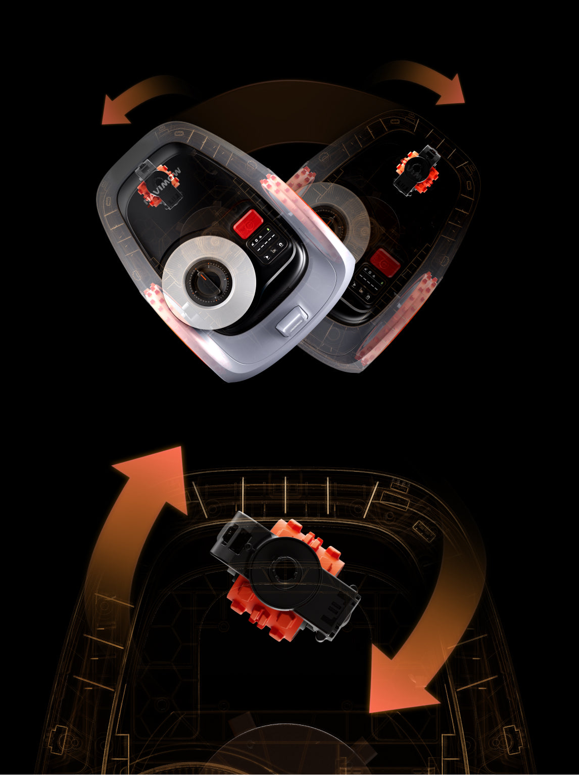
RTK counters VSLAM's weather woes, keeping steady in wet or dusty runs. Together, they max out reliability.Look at Navimow's EFLS 2.0 for a real-world win. Exact Fusion Locating System needs at least 10 satellites to hum, fusing them with sensor data for centimeter spots. RTK feeds the signals via mower and antenna, relayed through the charger for synced math that trims errors.Bad weather blocks satellites? Cameras kick in with visual cues. The process has three steps:

Step 1: Gather ViewsOn first map and full run, it snaps surroundings.

Step 2: Refine the MapBack at base, it polishes the visual layout—takes hours, pauses if interrupted.

Step 3: Spot with SightsWeak RTK? It matches live views to the map for ongoing place checks, no stops.VisionFence adds quick obstacle reads, keeping flow smooth.

Moreover, with the help of Visionfence, the robot can quickly respond to obstacles in front of it within a short time, ensuring an efficient mowing process.
Now, let’s enjoy the enhanced efficiency and exceptional lawn maintenance experience brought about by the combination of both RTK technologies in the Navimow robotic lawn mower.

Wrapping Up: Positioning's Big Role in Smarter Mowing
Positioning tech is the backbone of great lawn care—get it right, and mowers transform chores into set-it-and-forget-it ease. We've seen the trade-offs: RTK's precision with setup snags, VSLAM's flexibility but light sensitivity, lidar's clarity at a premium, UWB's indoor edge outdoors.Future tweaks will help, but RTK + VSLAM leads now for balance. Navimow's mower nails this duo—check it out for yard-ready proof.